Cadastral Parcels
Definition
Areas defined by cadastral registers or equivalent.
Description
The INSPIRE Directive focuses on the geographical part of cadastral data. In the INSPIRE context, cadastral parcels will be mainly used as locators for geo-information in general, including environmental data. As much as possible, in the INSPIRE context, cadastral parcels should be forming a partition of national territory. Cadastral parcel should be considered as a single area of Earth surface, under homogeneous real property rights and unique ownership (adapted from UN ECE 2004 and WG-CPI, 2006). Remark: By unique ownership is meant that the ownership is held by one or several owners for the whole parcel. By homogeneous property rights is meant that rights of ownership, leases and mortgages affect the whole parcel. This does not apply to specific rights as servitudes which may only affect part of the parcel.
In the definition given by the INSPIRE directive, or equivalent refers to all public agencies and institutions other than the main traditional/nominal cadastre or land registry, that register parts of the Earth’s surface such as special domains, urban cadastres, public lands, which spatially complement the registrations by the main cadastre or land registry.
Cadastral parcels are considered in the INSPIRE scope if they are available as vector data.
Rights and owners are out of the INSPIRE scope.
Buildings, land use, addresses are considered in other INSPIRE themes.
References
Models
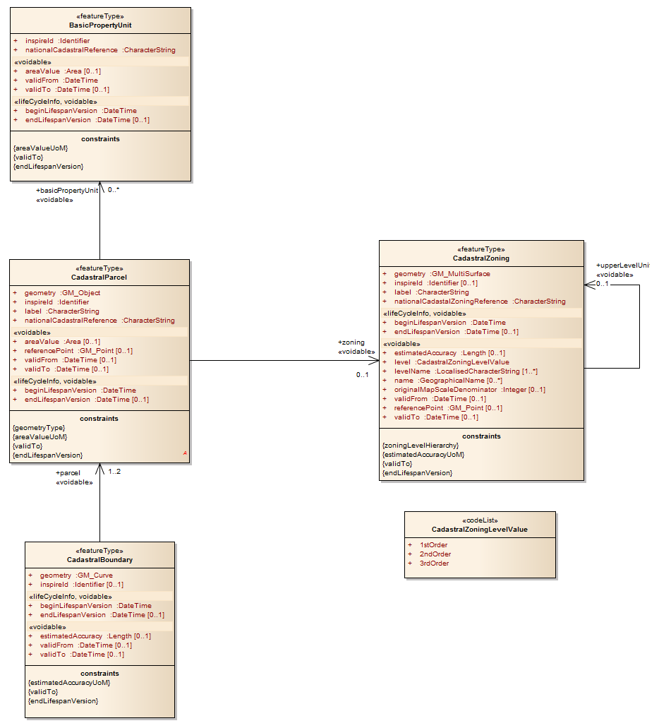
- class inspire_eu.models.cadastral_parcels.abstract.AbstractCadastralParcel(*args, **kwargs)[source]
Cadastral Parcels
- Definition
Areas defined by cadastral registers or equivalent
- Description
The INSPIRE Directive focuses on the geographical part of cadastral data In the INSPIRE context cadastral parcels will be mainly used as locators for geo information in general including environmental data. As much as possible in the INSPIRE context cadastral parcels should be forming a partition of national territory Cadastral parcel should be considered as a single area of Earth surface under homogeneous real property rights and unique ownership adapted from UN ECE 2004 and WG CPI 2006 Remark By unique ownership is meant that the ownership is held by one or several owners for the whole parcel By homogeneous property rights is meant that rights of ownership leases and mortgages affect the whole parcel This does not apply to specific rights as servitudes which may only affect part of the parcel
In the definition given by the INSPIRE directive or equivalent refers to all public agencies and institutions other than the main traditional nominal cadastre or land registry that register parts of the Earth s surface such as special domains urban cadastres public lands which spatially complement the registrations by the main cadastre or land registry.
Cadastral parcels are considered in the INSPIRE scope if they are available as vector data Rights and owners are out of the INSPIRE scope Buildings land use addresses are considered in other INSPIRE themes
- Parameters:
local_id (CharField) – Local id. A local identifier, assigned by the data provider. The local identifier is unique within the namespace, that is no other spatial object carries the same unique identifier.<br />NOTE It is the responsibility of the data provider to guarantee uniqueness of the local identifier within the namespace.
version_id (CharField) – Version id. The identifier of the particular version of the spatial object, with a maximum length of 25 characters. If the specification of a spatial object type with an external object identifier includes life-cycle information, the version identifier is used to distinguish between the different versions of a spatial object. Within the set of all versions of a spatial object, the version identifier is unique.<br />NOTE The maximum length has been selected to allow for time stamps based on ISO 8601, for example, “2007-02-12T12:12:12+05:30” as the version identifier.<br />NOTE 2 The property is void, if the spatial data set does not distinguish between different versions of the spatial object. It is missing, if the spatial object type does not support any life-cycle information.
begin_lifespan_version (DateTimeField) – Begin lifespan version. Registered area value giving quantification of the area projected on the horizontal plane of the cadastral parcel.
end_lifespan_version (DateTimeField) – End lifespan version. Date and time at which this version of the spatial object was superseded or retired in the spatial data set.
label (CharField) – Label. Text commonly used to display the cadastral parcel identification.
national_cadastral_reference (CharField) – National cadastral reference. Thematic identifier at national level, generally the full national code of the cadastral parcel. Must ensure the link to the national cadastral register or equivalent.
area_value (IntegerField) – Area value. Registered area value giving quantification of the area projected on the horizontal plane of the cadastral parcel.
valid_from (DateTimeField) – Valid from. Official date and time the cadastral parcel was/will be legally established.
valid_to (DateTimeField) – Valid to. Date and time at which the cadastral parcel legally ceased/will cease to be used.
geometry (MultiPolygonField) – Geometry. Geometry of the cadastral parcel.
reference_point (PointField) – Reference point. A point within the cadastral parcel. EXAMPLE The centroid of the cadastral parcel geometry.
Relationship fields:
- Parameters:
namespace (
ForeignKeytoNamespace) – Namespacearea_value_uom (
ForeignKeytoUnitOfMeasure) – Area value uom
- __init__(*args, **kwargs)
- class inspire_eu.models.cadastral_parcels.abstract.AbstractCadastralZoning(*args, **kwargs)[source]
CadastralZoning
- Definition
Intermediary areas used in order to divide national territory into cadastral parcels.
Description
Cadastral zonings are the intermediary areas (such as municipalities, sections, blocks, …) used in order to divide national territory into cadastral parcels. In the INSPIRE context, cadastral zonings are to be used to carry metadata information and to facilitate portrayal and search of data. Cadastral zonings have the following additional attributes:
a geometry
a national cadastral zoning reference
a name, if any
a level in the national cadastral hierarchy and the name of this level
portrayal attributes: reference point and label
metadata attributes: original map scale denominator and estimated accuracy
If cadastral zonings are provided, cadastral parcels shall belong to one cadastral zoning of lowest level. When several levels of zonings exist in a Member State, it must be ensured that the higher level units are composed of that of lower level.
References
- Parameters:
local_id (CharField) – Local id. A local identifier, assigned by the data provider. The local identifier is unique within the namespace, that is no other spatial object carries the same unique identifier.<br />NOTE It is the responsibility of the data provider to guarantee uniqueness of the local identifier within the namespace.
version_id (CharField) – Version id. The identifier of the particular version of the spatial object, with a maximum length of 25 characters. If the specification of a spatial object type with an external object identifier includes life-cycle information, the version identifier is used to distinguish between the different versions of a spatial object. Within the set of all versions of a spatial object, the version identifier is unique.<br />NOTE The maximum length has been selected to allow for time stamps based on ISO 8601, for example, “2007-02-12T12:12:12+05:30” as the version identifier.<br />NOTE 2 The property is void, if the spatial data set does not distinguish between different versions of the spatial object. It is missing, if the spatial object type does not support any life-cycle information.
begin_lifespan_version (DateTimeField) – Begin lifespan version. Registered area value giving quantification of the area projected on the horizontal plane of the cadastral parcel.
end_lifespan_version (DateTimeField) – End lifespan version. Date and time at which this version of the spatial object was superseded or retired in the spatial data set.
estimated_accuracy (FloatField) – Estimated accuracy. The estimated absolute positional accuracy of cadastral parcels within the cadastral zoning in the used INSPIRE coordinate reference system. Absolute positional accuracy is the mean value of the positional uncertainties for a set of positions, where the positional uncertainties are the distance between a measured position and what is considered as the corresponding true position.
geometry (MultiPolygonField) – Geometry. Geometry of the cadastral zoning.
label (CharField) – Label. Text commonly used to display the cadastral zoning identification.
name (CharField) – Name. Name of the cadastral zoning.
national_cadastal_zoning_reference (CharField) – National cadastal zoning reference. Text commonly used to display the cadastral zoning identification.
area_value (IntegerField) – Area value. Registered area value giving quantification of the area projected on the horizontal plane of the cadastral parcel.
original_map_scale_denominator (SmallIntegerField) – Original map scale denominator. The denominator in the scale of the original paper map (if any) to whose extent the cadastral zoning corresponds.
valid_from (DateTimeField) – Valid from. Official date and time the cadastral zoning was/will be legally established.
valid_to (DateTimeField) – Valid to. Date and time at which the cadastral zoning legally ceased/will cease to be used.
reference_point (PointField) – Reference point. A point within the cadastral zoning. EXAMPLE The centroid of the cadastral zoneing geometry.
Relationship fields:
- Parameters:
namespace (
ForeignKeytoNamespace) – Namespaceestimated_accuracy_uom (
ForeignKeytoUnitOfMeasure) – Estimated accuracy uom. Value of estimatedAccuracy shall be given in meterslevel (
ForeignKeytoCodeListValue) – Level. Level of the cadastral zoning in the national cadastral hierarchy.area_value_uom (
ForeignKeytoUnitOfMeasure) – Area value uomupper_level_unit (
ForeignKeytoAbstractCadastralZoning) – Upper level unit. Level of the cadastral zoning in the national cadastral hierarchy.
- __init__(*args, **kwargs)