Buildings
Definition
Geographical location of buildings specifications
Description
A building is a covered facility usable for the protection of humans animals things or the production of economic goods A building refers to any structure permanently constructed or erected on its site Information on location of buildings may be supplied as points or with the actual basic form of the building Usually buildings are part of cadastre On the local level buildings are available within the large scale cadastral maps or cadastral data sets and are geometrically represented as surfaces
Most buildings can be identified geocoded by address separate theme in INSPIRE
References
Models
- class inspire_eu.models.buildings.abstract.AbstractBuilding(*args, **kwargs)[source]
Abstract building
- Definition
Abstract spatial object type grouping the common semantic properties of the spatial object types Building and BuildingPart.
- References
https://inspire.ec.europa.eu/data-model/approved/r4618-ir/html/index.htm?goto=2:3:2:1:7900
- Parameters:
number_of_dwellings (SmallIntegerField) – Number of dwellings. A dwelling is a residential unit which may consist of one or several rooms designed for the occupation of households.<br />NOTE: In the data sets including building units, a dwelling is a residential building unit or, only when that building has no building units, a residential building<br />EXAMPLES: a single building dwelling could be a detached or semi-detached house. A block of flats will contain multiple dwellings determined by the number of individual flats.
number_of_building_units (SmallIntegerField) – Number of building units. Number of building units in the building. A BuildingUnit is a subdivision of Building with its own lockable access from the outside or from a common area (i.e. not from another BuildingUnit), which is atomic, functionally independent, and may be separately sold, rented out, inherited, etc.<br />Building units are spatial objects aimed at subdividing buildings and/or building parts into smaller parts that are treated as separate entities in daily life. A building unit is homogeneous, regarding management aspects.<br />EXAMPLES: It may be e.g. an apartment in a condominium, a terraced house, or a shop inside a shopping arcade.<br />NOTE 1: According to national regulations, a building unit may be a flat, a cellar, a garage or set of a flat, a cellar and a garage.<br />NOTE 2: According to national regulation, a building that is one entity for daily life (typically, a single family house) may be considered as a Building composed of one BuildingUnit or as a Building composed of zero BuildingUnit.
number_of_floors_above_ground (SmallIntegerField) – Number of floors above ground. Number of floors above ground.
- __init__(*args, **kwargs)
- class inspire_eu.models.buildings.abstract.AbstractBuildingAndBuildingUnitInfo(*args, **kwargs)[source]
Building and building unit info
- Definition
Abstract spatial object type grouping the additional properties that are common to Building, Building Part and BuildingUnit.
Description
NOTE 1: The additional properties are those that are not already included in the base application schema.
NOTE 2: These additional properties concern mainly the official information that may be attached to buildings / building parts or to building units.
- Parameters:
connection_to_electricity (BooleanField) – Connection to electricity
connection_to_gas (BooleanField) – Connection to gas
connection_to_sewage (BooleanField) – Connection to sewage
connection_to_water (BooleanField) – Connection to water
- __init__(*args, **kwargs)
- class inspire_eu.models.buildings.abstract.AbstractBuildingCurrentUse(*args, **kwargs)[source]
Current use
- Definition
This data type enables to detail the current use(s).
- References
https://inspire.ec.europa.eu/data-model/approved/r4618-ir/html/index.htm?goto=2:3:2:1:7906
- Parameters:
percentage (SmallIntegerField) – Percentage. The proportion of the real world object, given as a percentage, devoted to this current use. <br />NOTE: The percentage of use is generally the percentage of floor area dedicated to this given use. If it is not the case, it is recommended to explain what the percentage refers to in metadata (template for additional information)
Relationship fields:
- Parameters:
current_use (
ForeignKeytoCodeListValue) – Current use. Current use
- __init__(*args, **kwargs)
- class inspire_eu.models.buildings.abstract.AbstractBuildingExtended2D(*args, **kwargs)[source]
BuildingsExtended2D
- Definition
The BuildingsExtended2D profile is a semantic extension of Buildings2D profile with additional thematic attributes (material of construction, official area or value, connection to utility networks…), classes (building units, installations, other constructions) and references to other data (like cadastral data and addresses).
- References
https://inspire.ec.europa.eu/documents/Data_Specifications/INSPIRE_DataSpecification_BU_v3.0.pdf
- Parameters:
number_of_dwellings (SmallIntegerField) – Number of dwellings. A dwelling is a residential unit which may consist of one or several rooms designed for the occupation of households.<br />NOTE: In the data sets including building units, a dwelling is a residential building unit or, only when that building has no building units, a residential building<br />EXAMPLES: a single building dwelling could be a detached or semi-detached house. A block of flats will contain multiple dwellings determined by the number of individual flats.
number_of_building_units (SmallIntegerField) – Number of building units. Number of building units in the building. A BuildingUnit is a subdivision of Building with its own lockable access from the outside or from a common area (i.e. not from another BuildingUnit), which is atomic, functionally independent, and may be separately sold, rented out, inherited, etc.<br />Building units are spatial objects aimed at subdividing buildings and/or building parts into smaller parts that are treated as separate entities in daily life. A building unit is homogeneous, regarding management aspects.<br />EXAMPLES: It may be e.g. an apartment in a condominium, a terraced house, or a shop inside a shopping arcade.<br />NOTE 1: According to national regulations, a building unit may be a flat, a cellar, a garage or set of a flat, a cellar and a garage.<br />NOTE 2: According to national regulation, a building that is one entity for daily life (typically, a single family house) may be considered as a Building composed of one BuildingUnit or as a Building composed of zero BuildingUnit.
number_of_floors_above_ground (SmallIntegerField) – Number of floors above ground. Number of floors above ground.
height_below_ground (FloatField) – Height below ground
number_of_floors_below_ground (SmallIntegerField) – Number of floors below ground. Number of floors below ground.
Relationship fields:
- Parameters:
height_below_ground_uom (
ForeignKeytoUnitOfMeasure) – Height below ground uom
- __init__(*args, **kwargs)
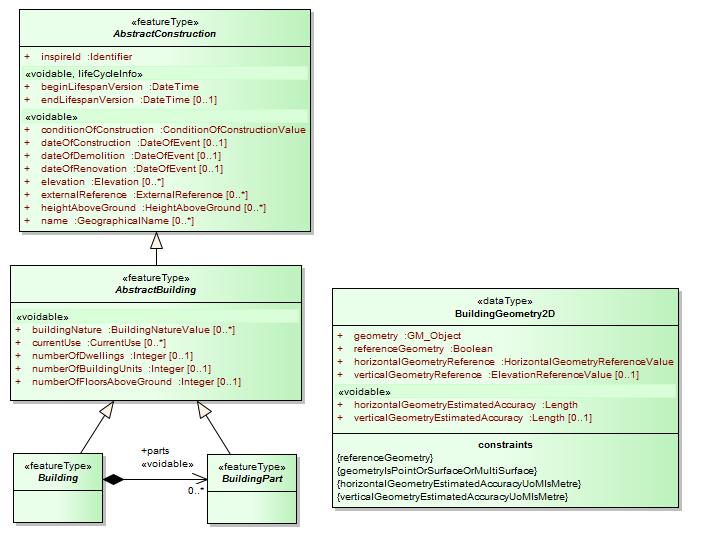
- class inspire_eu.models.buildings.abstract.AbstractBuildingGeometry2D(*args, **kwargs)[source]
Building geometry 2D
- Definition
This data types includes the geometry of the building and metadata information about which element of the building was captured and how.
- References
https://inspire.ec.europa.eu/data-model/approved/r4618-ir/html/index.htm?goto=2:3:2:1:7904
- Parameters:
geometry (MultiPolygonField) – Geometry. 2D or 2.5D geometric representation
reference_geometry (BooleanField) – Reference geometry. The geometry to be taken into account by view services, for portrayal.<br />NOTE 1: In case of multiple representation by point and by surface, it is generally recommended to provide the surface as reference geometry.<br />NOTE 2: The geometric representation whose referenceGeometry is true may also be used preferably for spatial queries by download services (WFS) or by Geographical Information System (GIS).
horizontal_geometry_estimated_accuracy (FloatField) – Horizontal geometry estimated accuracy. The estimated absolute positional accuracy of the (X,Y) coordinates of the building geometry, in the INSPIRE official Coordinate Reference System. Absolute positional accuracy is defined as the mean value of the positional uncertainties for a set of positions where the positional uncertainties are defined as the distance between a measured position and what is considered as the corresponding true position.<br />NOTE: This mean value may come from quality measures on a homogeneous population of buildings or from an estimation based on the knowledge of the production processes and of their accuracy.
vertical_geometry_estimated_accuracy (CharField) – Vertical geometry estimated accuracy. Value of estimatedAccuracy shall be given in meters
Relationship fields:
- Parameters:
horizontal_geometry_reference (
ForeignKeytoCodeListValue) – Horizontal geometry reference. Element of the building that was captured by (X,Y) coordinates.horizontal_geometry_estimated_accuracy_uom (
ForeignKeytoUnitOfMeasure) – Horizontal geometry estimated accuracy uomvertical_geometry_estimated_accuracy_uom (
ForeignKeytoUnitOfMeasure) – Vertical geometry estimated accuracy uomvertical_geometry_reference (
ForeignKeytoCodeListValue) – Vertical geometry reference. Element of the building that was captured by vertical coordinates.
- __init__(*args, **kwargs)
- class inspire_eu.models.buildings.abstract.AbstractBuildingInfo(*args, **kwargs)[source]
Building info
- Definition
Abstract spatial object type grouping the additional specific properties of Building and Building Part
Description
NOTE 1: The additional properties are those that are not already included in the base application schema.
NOTE 2: The specific properties are the properties that apply to Building and BuildingPart without applying to BuildingUnit.
Warning
Pending ToDo:
floorDescription: FloorDescription [0..*]
floorDistribution: FloorRange [1..*]
heightBelowGround: Length [0..1]
materialOfFacade: MaterialOfFacadeValue [0..*]
materialOfRoof: MaterialOfRoofValue [0..*]
materialOfStructure: MaterialOfStructureValue [0..*]
numberOfFloorsBelowGround: Integer [0..1]
roofType: RoofTypeValue [0..*]
- Parameters:
connection_to_electricity (BooleanField) – Connection to electricity
connection_to_gas (BooleanField) – Connection to gas
connection_to_sewage (BooleanField) – Connection to sewage
connection_to_water (BooleanField) – Connection to water
- __init__(*args, **kwargs)
- class inspire_eu.models.buildings.abstract.AbstractBuildingNature(*args, **kwargs)[source]
Building nature
- Definition
Characteristic of the building that makes it generally of interest for mappings applications. The characteristic may be related to the physical aspect and/or to the function of the building.
- Description
This attribute focuses on the physical aspect of the building; however, this physical aspect is often expressed as a function (e.g. stadium, silo, windmill); this attribute aims to fulfil mainly mapping purposes and addresses only specific, noticeable buildings.
- Vocabulary
Relationship fields:
- Parameters:
nature (
ForeignKeytoCodeListValue) – Nature. Characteristic of the building that makes it generally of interest for mappings applications. The characteristic may be related to the physical aspect and/or to the function of the building.<br />This attribute focuses on the physical aspect of the building; however, this physical aspect is often expressed as a function (e.g. stadium, silo, windmill); this attribute aims to fulfil mainly mapping purposes and addresses only specific, noticeable buildings.
- __init__(*args, **kwargs)
- class inspire_eu.models.buildings.abstract.AbstractBuildingUnit(*args, **kwargs)[source]
Building unit
- Definition
Abstract spatial object type grouping the semantic properties of building units. A BuildingUnit is a subdivision of Building with its own lockable access from the outside or from a common area (i.e. not from another BuildingUnit), which is atomic, functionally independent, and may be separately sold, rented out, inherited, etc.
Description
Building units are spatial objects aimed at subdividing buildings and/or building parts into smaller parts that are treated as separate entities in daily life. A building unit is homogeneous, regarding management aspects.
EXAMPLES: It may be e.g. an apartment in a condominium, a terraced house, or a shop inside a shopping arcade.
NOTE 1: According to national regulations, a building unit may be a flat, a cellar, a garage or set of a flat, a cellar and a garage.
NOTE 2: According to national regulation, a building that is one entity for daily life (typically, a single family house) may be considered as a Building composed of one BuildingUnit or as a Building composed of zero BuildingUnit.
- Parameters:
connection_to_electricity (BooleanField) – Connection to electricity
connection_to_gas (BooleanField) – Connection to gas
connection_to_sewage (BooleanField) – Connection to sewage
connection_to_water (BooleanField) – Connection to water
- __init__(*args, **kwargs)
- class inspire_eu.models.buildings.abstract.AbstractConstruction(*args, **kwargs)[source]
Abstract construction
- Definition:
Abstract spatial object type grouping the semantic properties of buildings, building parts and of some optional spatial object types that may be added in order to provide more information about the theme Buildings.
- Description:
The optional spatial object types that may be added to core profiles are described in the extended profiles. The ones inheriting from the attributes of AbstractConstruction are Installation and OtherConstruction
- References
https://inspire.ec.europa.eu/data-model/approved/r4618-ir/html/index.htm?goto=2:3:2:1:7895
- Parameters:
local_id (CharField) – Local id. A local identifier, assigned by the data provider. The local identifier is unique within the namespace, that is no other spatial object carries the same unique identifier.<br />NOTE It is the responsibility of the data provider to guarantee uniqueness of the local identifier within the namespace.
version_id (CharField) – Version id. The identifier of the particular version of the spatial object, with a maximum length of 25 characters. If the specification of a spatial object type with an external object identifier includes life-cycle information, the version identifier is used to distinguish between the different versions of a spatial object. Within the set of all versions of a spatial object, the version identifier is unique.<br />NOTE The maximum length has been selected to allow for time stamps based on ISO 8601, for example, “2007-02-12T12:12:12+05:30” as the version identifier.<br />NOTE 2 The property is void, if the spatial data set does not distinguish between different versions of the spatial object. It is missing, if the spatial object type does not support any life-cycle information.
begin_lifespan_version (DateTimeField) – Begin lifespan version. Registered area value giving quantification of the area projected on the horizontal plane of the cadastral parcel.
end_lifespan_version (DateTimeField) – End lifespan version. Date and time at which this version of the spatial object was superseded or retired in the spatial data set.
date_of_construction_beginning (DateTimeField) – Date of construction beginning. Beginning date of construction
date_of_construction_end (DateTimeField) – Date of construction end. End of date of construction
date_of_construction_any_point (DateTimeField) – Date of construction any point. Any point of date of construction
date_of_demolition_beginning (DateTimeField) – Date of demolition beginning. Beginning date of demolition
date_of_demolition_end (DateTimeField) – Date of demolition end. End of date of demolition
date_of_demolition_any_point (DateTimeField) – Date of demolition any point. Any point of date of demolition
date_of_renovation_beginning (DateTimeField) – Date of renovation beginning. Beginning date of last major renovation
date_of_renovation_end (DateTimeField) – Date of renovation end. End of date of last major renovation
date_of_renovation_any_point (DateTimeField) – Date of renovation any point. Any point of date of last major renovation
Relationship fields:
- Parameters:
namespace (
ForeignKeytoNamespace) – Namespacecondition_of_construction (
ForeignKeytoCodeListValue) – Condition of construction. Status of the construction.<br />EXAMPLES: functional, projected, ruin
- __init__(*args, **kwargs)
- class inspire_eu.models.buildings.abstract.AbstractDocument(*args, **kwargs)[source]
Document
- Definition
Any document providing information about the building or building part or building unit.
- Description
- EXAMPLES: the building permit, a photo of facade or inner yard, a sketch of interior, the building code, the
energy performance assessment, an emergency plan
- Parameters:
document_link (URLField) – Document link. The Internet address where the document may be found.
date (DateTimeField) – Date. Date of validity of the document
document_description (TextField) – Document description. A short text providing overview of the document content. May be just title of the document
Relationship fields:
- Parameters:
source_status (
ForeignKeytoCodeListValue) – Source status. The status of the document, i.e. this attribute indicates if the document comes from official source or not
- __init__(*args, **kwargs)
- class inspire_eu.models.buildings.abstract.AbstractElevation(*args, **kwargs)[source]
Elevation
- Definition
This data types includes the elevation value itself and information on how this elevation was measured.
- References
https://inspire.ec.europa.eu/data-model/approved/r4618-ir/html/index.htm?goto=2:3:2:1:7901
- Parameters:
value (FloatField) – Value. Vertically-constrained dimensional property consisting of an absolute measure referenced to a well-defined surface which is commonly taken as origin (geoïd, water level, etc.).<br />Source: adapted from the definition given in the data specification of the theme Elevation.
Relationship fields:
- Parameters:
reference (
ForeignKeytoCodeListValue) – Reference. Element where the elevation was measured.value_uom (
ForeignKeytoUnitOfMeasure) – Value uom. Value of Elevation shall be given in meters
- __init__(*args, **kwargs)
- class inspire_eu.models.buildings.abstract.AbstractEnergyPerformance(*args, **kwargs)[source]
Energy performance
- Definition
The energy performance of the building or building part or building unit
- Description
NOTE: The energy performance is required by the Energy Performance of Building Directive for the new buildings being rent or sold.
- Parameters:
date_of_assessment (DateTimeField) – Date of assessment. Date and time at which this version of the spatial object was inserted or changed in the spatial data set.
assessment_method (CharField) – Assessment method. The reference to the document describing the assessment method of energy performance
Relationship fields:
- Parameters:
energy_performance_value (
ForeignKeytoCodeListValue) – Energy performance value. The date when the energy performance of the building or building unit was assessed
- __init__(*args, **kwargs)
- class inspire_eu.models.buildings.abstract.AbstractExternalReference(*args, **kwargs)[source]
External reference
- Definition
Reference to an external information system containing any piece of information related to the spatial object.
- References
https://inspire.ec.europa.eu/data-model/approved/r4618-ir/html/index.htm?goto=2:3:2:1:7908
- Parameters:
information_system (URLField) – Information system. Uniform Resource Identifier of the external information system
information_system_name (CharField) – Information system name. The name of the external information systemEXAMPLES: Danish Register of Dwellings, Spanish Cadastre
reference (CharField) – Reference. Thematic identifier of the spatial object or of any piece of information related to the spatial object.<br />NOTE: This reference will act as a foreign key to implement the association between the spatial object in the INSPIRE data set and in the external information system<br />EXAMPLE: The cadastral reference of a given building in the national cadastral register.
- __init__(*args, **kwargs)
- class inspire_eu.models.buildings.abstract.AbstractHeightAboveGround(*args, **kwargs)[source]
Height above ground
- Definition
Vertical distance (measured or estimated) between a low reference and a high reference.
- References
https://inspire.ec.europa.eu/data-model/approved/r4618-ir/html/index.htm?goto=2:3:2:1:7898
- Parameters:
value (SmallIntegerField) – Value. Value of the height above ground
Relationship fields:
- Parameters:
height_reference (
ForeignKeytoCodeListValue) – Height reference. Element used as the high reference.<br />EXAMPLE: The height of the building has been captured up to the top of building.low_reference (
ForeignKeytoCodeListValue) – Low reference. Element as the low reference.<br />EXAMPLE: The height of the building has been captured from its the lowest ground point.status (
ForeignKeytoCodeListValue) – Status. The way the height has been captured.
- __init__(*args, **kwargs)
- class inspire_eu.models.buildings.abstract.AbstractOfficialArea(*args, **kwargs)[source]
Official area
- Definition
This data types includes the official area of the building, building part or building unit and information about the exact meaning of this area.
- Parameters:
value (FloatField) – Value. The value of the official area
height_parameter (FloatField) – Height parameter. The height parameter used to differentiate internal primary area of internal other area, if the official area is referenced using the CLGE measurement code for the floor area of buildings
Relationship fields:
- Parameters:
reference (
ForeignKeytoCodeListValue) – Reference. The type of official area may be described either by using the values provided by the CLGE measurement code for the floor area of buildings (which values are provided by the CLGE_OfficialAreaReferenceValue) or by using another standard (which values are provided by the empty code list OtherStandard OfficialAreaReferenceValue, this code list having to be defined at Member State level)..value_uom (
ForeignKeytoUnitOfMeasure) – Value uomheight_parameter_uom (
ForeignKeytoUnitOfMeasure) – Height parameter uom. Value of Elevation shall be given in meters
- __init__(*args, **kwargs)
- class inspire_eu.models.buildings.abstract.AbstractOtherConstruction(*args, **kwargs)[source]
Abstract other construction
- Definition
Abstract spatial object type grouping the semantic properties of other constructions. An other construction is a self-standing construction that belongs to theme Buildings and that is not a Building
Description
NOTE 1: the main difference between a building and an other construction is the fact that an other construction does not need to be enclosed.
NOTE 2: the other constructions to be considered under scope of theme Buildings are the constructions that are not present in another INSPIRE theme and that are necessary for environmental use cases, such as the ones considered in this data specification.
EXAMPLES: bridge, acoustic fence, city wall.
- Parameters:
local_id (CharField) – Local id. A local identifier, assigned by the data provider. The local identifier is unique within the namespace, that is no other spatial object carries the same unique identifier.<br />NOTE It is the responsibility of the data provider to guarantee uniqueness of the local identifier within the namespace.
version_id (CharField) – Version id. The identifier of the particular version of the spatial object, with a maximum length of 25 characters. If the specification of a spatial object type with an external object identifier includes life-cycle information, the version identifier is used to distinguish between the different versions of a spatial object. Within the set of all versions of a spatial object, the version identifier is unique.<br />NOTE The maximum length has been selected to allow for time stamps based on ISO 8601, for example, “2007-02-12T12:12:12+05:30” as the version identifier.<br />NOTE 2 The property is void, if the spatial data set does not distinguish between different versions of the spatial object. It is missing, if the spatial object type does not support any life-cycle information.
begin_lifespan_version (DateTimeField) – Begin lifespan version. Registered area value giving quantification of the area projected on the horizontal plane of the cadastral parcel.
end_lifespan_version (DateTimeField) – End lifespan version. Date and time at which this version of the spatial object was superseded or retired in the spatial data set.
date_of_construction_beginning (DateTimeField) – Date of construction beginning. Beginning date of construction
date_of_construction_end (DateTimeField) – Date of construction end. End of date of construction
date_of_construction_any_point (DateTimeField) – Date of construction any point. Any point of date of construction
date_of_demolition_beginning (DateTimeField) – Date of demolition beginning. Beginning date of demolition
date_of_demolition_end (DateTimeField) – Date of demolition end. End of date of demolition
date_of_demolition_any_point (DateTimeField) – Date of demolition any point. Any point of date of demolition
date_of_renovation_beginning (DateTimeField) – Date of renovation beginning. Beginning date of last major renovation
date_of_renovation_end (DateTimeField) – Date of renovation end. End of date of last major renovation
date_of_renovation_any_point (DateTimeField) – Date of renovation any point. Any point of date of last major renovation
Relationship fields:
- Parameters:
namespace (
ForeignKeytoNamespace) – Namespacecondition_of_construction (
ForeignKeytoCodeListValue) – Condition of construction. Status of the construction.<br />EXAMPLES: functional, projected, ruinother_construction_nature (
ForeignKeytoCodeListValue) – Other construction nature. Characteristic of the building that makes it generally of interest for mappings applications. The characteristic may be related to the physical aspect and/or to the function of the building.<br />This attribute focuses on the physical aspect of the building; however, this physical aspect is often expressed as a function (e.g. stadium, silo, windmill); this attribute aims to fulfil mainly mapping purposes and addresses only specific, noticeable buildings.
- __init__(*args, **kwargs)